Virginia Beach uses voice and data science to strengthen community preparedness
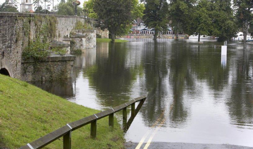
As sea levels rise and storm surges from hurricanes and Nor’easters become more common, community preparedness for flooding is a top priority for the City of Virginia Beach.
The City of Virginia Beach plays a key role in the regional collaboration, StormSense, which uses Internet of Things (IoT) water level sensors to monitor flood-prone areas and includes the cities Newport News, Norfolk, and the Virginia Institute of Marine Science (VIMS). At the 2018 Transforming Local Government 2018 conference, the City of Virginia presented their smart city innovation.
In the past four years, two proposals were submitted to the city as Capital Improvement Programs for consideration in addition to other active programs. These included utilizing Internet of Things (IoT) sensors to improve real-time data collection, understanding the impact of weather patterns on the flow of water, and the creation of more accurate and useful predictions. As part of this effort, the city reviewed emerging research, and invited faculty at VIMS to present their findings and proposals, and as a result, the city participated in Smart Cities initiatives through USIgnite/NIST GCTC with VIMS, Newport News, and Norfolk.
This project brings innovation to Virginia Beach in six ways:
- testing multiple sensor technologies and their communication protocols, energy requirements, and accuracy;
- leveraging a high-resolution hydrodynamic model, results for street-level flood forecasting;
- disparate data integration architecture in near real-time;
- leveraging multi-cloud environments using Amazon Web Services for data, AI, and voice-response query integration;
- data presentation and big data support using Microsoft Cloud; and
- spatial mapping of inundation vulnerability scenarios.
Utilizing technology
These innovations help modernize and allow citizen stakeholders across the city to better understand the weather risks. This is accomplished through the installation of additional sensors by the city to augment the utility of existing water level, streamflow, and rainfall sensors provided by federal agencies, and providing aggregated datasets to StormSense for improved predictions. These datasets will be used to perform analyses for: a custom-tailored approach to assessing neighborhood-level flood risk, comparison of actual versus perceived risk assessments, effective mitigation techniques, and use these to make strategic decisions that will have a real-world impact on the community and its citizens.
The city’s GIS coordinator and teams in the city over the last four years began engaging in a take-charge approach to address weather-related flooding issues such as hurricanes and nor’easters by proposing multiple projects at the Enterprise GIS Policy Board. Initially, the city evaluated recent advances in sensor technologies and high-resolution hydrodynamic modeling research to leverage the Lidar topography data that the city acquired.
As part of the modeling effort, the city was engaged in reviewing the latest research being performed at universities using high-resolution hydrodynamic modeling to address street-level flooding. Faculty from VIMS were invited to present their research and they jointly proposed projects. Ultimately, the city reviewed the projects and funded the “StormSenseVB” project for the installation of ultrasonic water level sensors. As part of this uniquely proactive effort, the city also participated with Newport News, Norfolk, and VIMS in NIST’s GCTC in 2016-2017 and played a key role with regional and national stakeholders as we became part of the StormSense action cluster and supercluster in public safety, as The White House and NIST announced the flood monitoring solution to be a “Replicable Smart City Technology” in September 2016.
Replicating technology
Replicability of this concept is demonstrated in recent prototypes developed within the past two years in using new state-of-the-art high resolution hydrodynamic models tested in other urban environments along the U.S. East Coast focusing upon hindcast calibration of model accuracy in. Outside Virginia Beach, project replication in Newport News and Norfolk have resulted in these neighbouring communities also installing sensors through StormSense in 2017. StormSense is also easily scalable by building upon the early successes of a prototype hydrodynamic modeling grid established to help model tidal flooding.
The approach can then be expanded upon in two ways, the first, temporally to provide more accurate forecasts farther into the future using atmospheric model weather predictions to forecast flooding from storm surge, rain, and tides at the street-level scale. And second, spatially extend the forecasting coverage to enhance disaster preparedness and fundamentally change the way we plan for and take proactive action for flood-related hazards.
There are bureaucratic, monetary, scientific, and technological obstacles to addressing coastal flooding in a region that is inundation-prone. Getting local governments to collaborate together can be challenging at times as well, since they often compete for grants and state or federal funding for their individual cities’ planned improvement projects, and it can be difficult when some cities are more frequently the beneficiary of those grants than others.
Ultimately, flooding is not a unique problem to Virginia Beach or even to Hampton Roads, Virginia, as a region. Rising sea levels and the risks associated with it pose a threat to communities around the world and with the technological advances being made here and elsewhere, it will become easier to prepare communities for these events.